Hello from Freegrow!
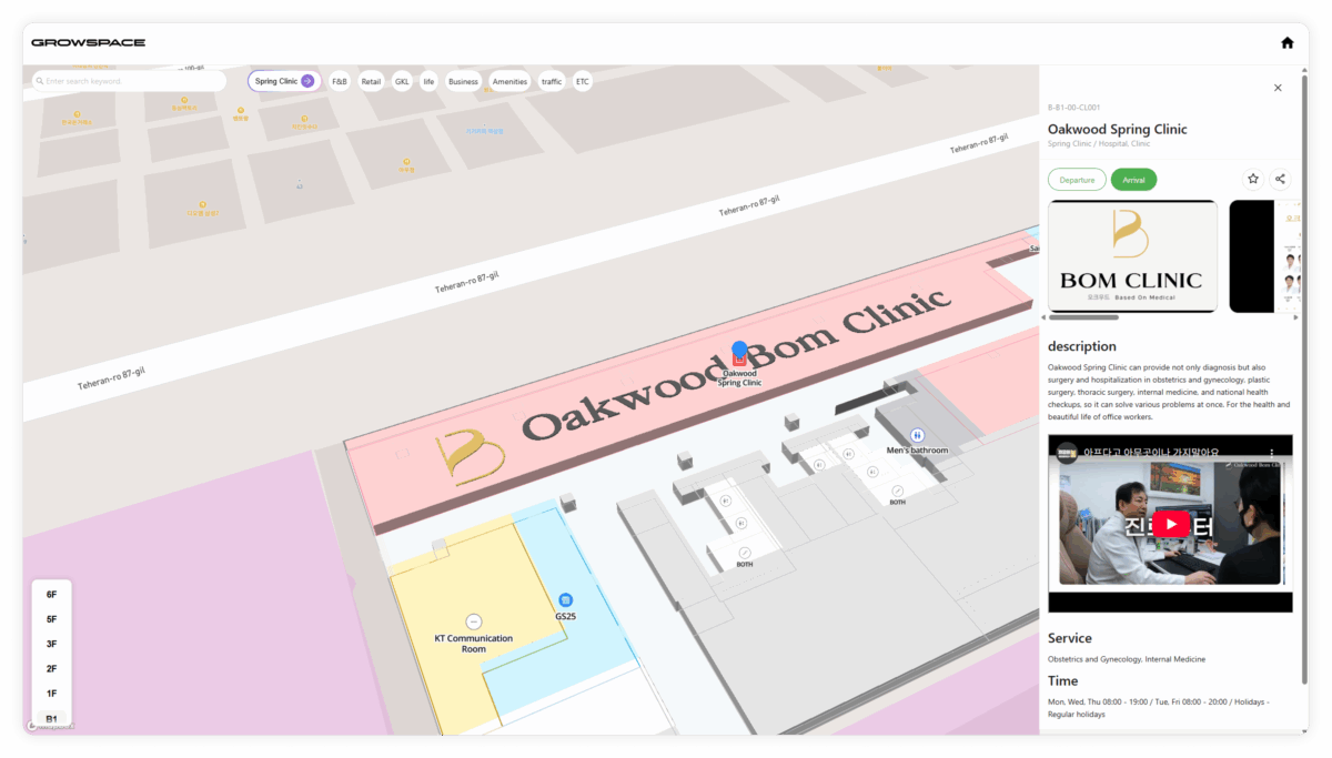
“How can I view the details of a specific place on a 3D map?“,
“Can we customize the name or description of a place for our own service?”
We get these questions all the time.
With our GROWSPACE Map API, you can get and update place details directly on a digital map.
This feature is especially useful for systems like map-based monitoring tools or space operation platforms.
In this post, we’ll walk you through how to use the Get and Update Place Detail API.
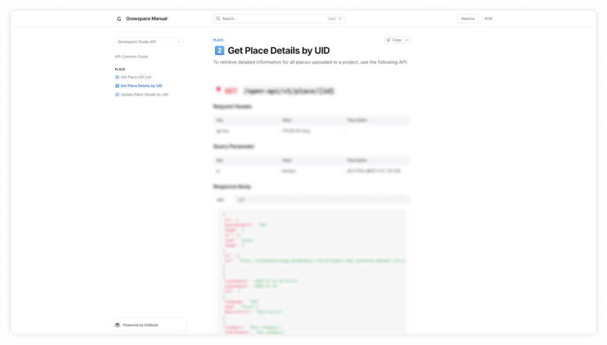
1️⃣ Get Place Details by UID
Have you ever wondered what kind of data should appear when you click on a place on the map?
- Content linked to the place
- Categories
- Created date or last updated date
A simple list API is not enough to provide this level of detail.
That’s why we provide the UID-based Get Place Detail API.
When should you use it?
This API is helpful in the following cases.
- When users tap on a spot in a 3D exhibition or tourist guide map to get more info
- When a monitoring system needs to check real-time status or linked content of a place
- When a CMS or admin tool needs to check tags or connected status
- When space-specific data like building/floor/room details is needed
- When you want to show custom content or update place info in a digital map
It’s great for services that use indoor 3D maps or location search and routing features.
Especially in control systems where monitoring and analytics matter, this API becomes a powerful tool.
How to use the API?
- Method:
GET - Endpoint:
/open-api/v1/place/{id}
Make sure to include the placeAreaUid parameter in the request.
With just this UID, you can fetch place details of the place.
It’s perfect for managing venues like exhibition halls, stores, or buildings.
The response includes.
- Place type
- Images
- Created/updated date
- Supported languages
- Place name
- Description
- Category
Example response :
{
"id": 1,
"placeAreaUid": "A01",
"image": {
"id": 11,
"type": "place",
"image": [
{
"id": 11,
"url": "https://firebasestorage.googleapis.com/v0/b/grow-maps-platform.appspot.com/o/project_thumbnail%2Fd6a71758-8d1b-4e92-a434-8f866066454b.webp?alt=media"
}
]
},
"createDate": "2025-07-16 10:49:44",
"updateDate": "2025-07-16",
"trn": [
{
"language": "def",
"name": "Place 1",
"description": "description"
}
],
"category": "Main category",
"subCategory": "Sub category"
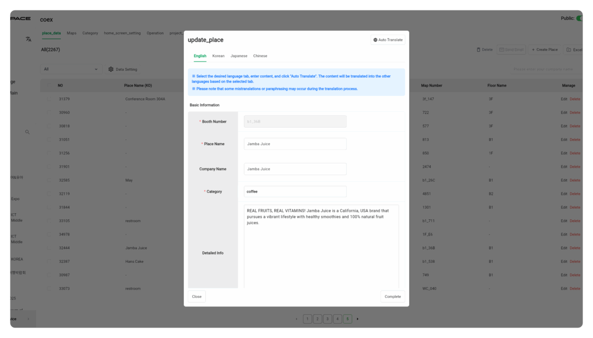
}2️⃣ Update Place Details
“The facility name has changed. We need to update it on the 3D map.”,
“We want to change the description or tags by season.”
If your environment requires frequent real-time updates, this feature is essential.
That’s where the Update Place Detail API comes in.
When should you use it?
You can use this API in cases like these:
- Selecting a specific place using UID to efficiently update location info on a facility or exhibition guide map in real time
- Customizing descriptions or adding multilingual content for marketing
- Making maps more manageable after deployment
- Updating space data for control systems based on events or operational changes
How to use the API?
- Method:
PUT - Endpoint:
/open-api/v1/place/{id}
Make sure to include the placeAreaUid parameter in the request.
Fields you can update:
categoryId: CategoryplaceAreaUid: Place UIDimageId: Image IDname: Place Namelanguage: Language (base or translated)- You can select up to 4 languages, and either auto-translate or provide language-specific content.
description: Description
{
"categoryId" : 1,
"placeAreaUid" : "B01",
"imageId" : 13,
"trn" : [
{
"language" : "def",
"description" : "description",
"name" : "place name 1"
}
]
}
Example response :
{
"id": 2,
"placeAreaUid": "B01",
"image": {
"id": 13,
"type": "place",
"image": [
{
"id": 12,
"url": "https://…"
}
]
},
"createDate": "2025-07-16 10:49:52",
"updateDate": "2025-07-16",
"trn": [
{
"language": "def",
"name": "place name 1",
"description": "description"
}
],
"category": "Main category",
"subCategory": "Sub category"
}
Once this is done, the place name and coordinates on your map are updated, and app users will see the new details right away.
This is a core API for automating place data management.
Where to Access the API
You can find more details in the test version of our API documentation (link in the comments).
It covers:
- How to get your API key
- How to use the API
- What the response structure looks like
Need help issuing your key or testing the integration? Feel free to contact us — we’ll be happy to assist!
What’s next?
In the next post,
We’ll cover how to load a full project’s GeoJSON file, including how to visualize separate floors on the map.
If that’s something you’re curious about, stay tuned!
The GROWSPACE Map API is more than just a viewer.
It’s the backbone of digital twin services and map-based monitoring and control systems.
We’ll keep sharing practical APIs you can use right away in your own services.
See you in the next post!