
What Is Trilateration?
Trilateration is a method of calculating a tag’s position based on distance measurements between the tag and three or more anchors.
It is the most common and accurate method used in UWB indoor positioning systems.
How It Works
- Tag → Anchor Signal Transmission
When the tag transmits a signal, nearby UWB anchors receive it. - Anchor → Tag Distance Measurement
The anchor calculates the distance (in meters) based on the signal’s round-trip time (TOF, Time of Flight). - Position Calculation
The tag’s position is calculated from distance measurements taken by three or more anchors.
The calculation is based on the concept of intersecting circles.
Example:
If anchors A, B, and C are 3m, 4m, and 5m away respectively,
the tag’s position is where circles of radius 3/4/5m, centered on each anchor, overlap.
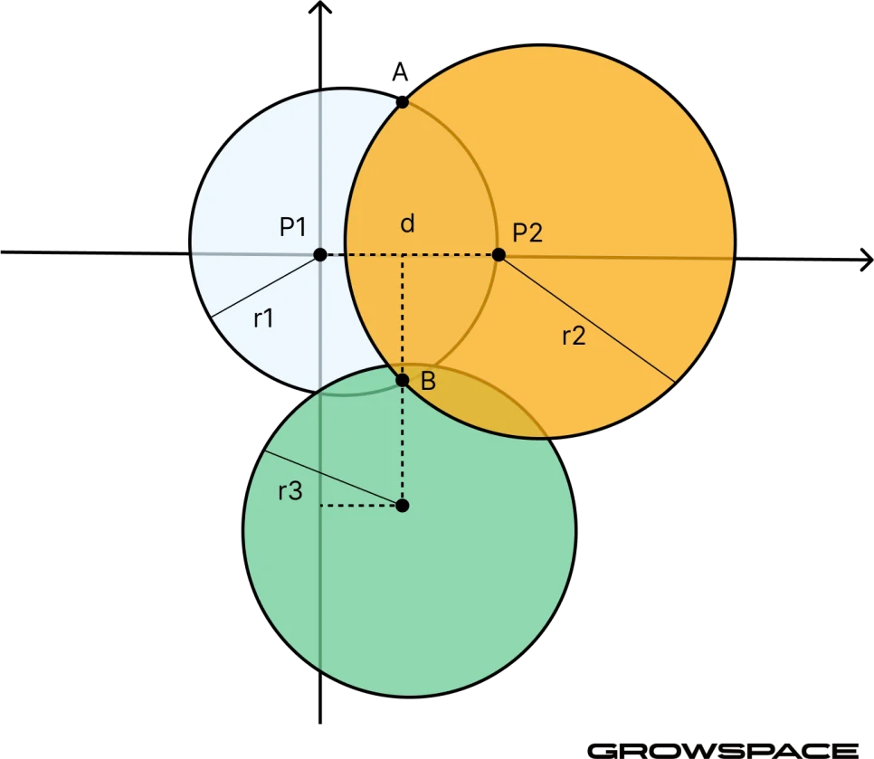
- P1, P2, P3 (the centers of the sky-blue, yellow, and green circles) → Anchors
- r1, r2, r3 → The distance from each anchor to the tag, as measured
- B → The point where the circles meet, which is the tag’s position (B)
Installation Precautions
- Install at least 3 anchors
Trilateration is not possible with 2 or fewer anchors. - Anchor coordinates (X, Y, Z) must be entered accurately
Entering coordinates with errors will make the RTLS results inaccurate as well. - Do not omit the Z coordinate
Since distance calculations are based on 3D space,
omitting the Z (height) value can distort the distance itself. - Minimum distance between anchors: 2m or more
If anchors are too close together, the small distance difference makes accurate calculation difficult. - Keep the tag within the anchors’ central coverage area
Accuracy can drop outside the edges of the installation area.
Example Application
- Example trilateration result based on 3 anchors
- A: (0, 0, 2)
- B: (6, 0, 2)
- C: (3, 5, 2)
- Tag: (3, 2, 1.5) → can be calculated via trilateration
Common Issues and Causes
| Symptom | Cause |
|---|---|
| RTLS position jumps around | Insufficient number of anchors, incorrect coordinate entry, obstacle interference |
| Distance is measured but position isn’t shown | Fewer than 3 anchors, or position coordinates not entered |
| Position appears outside the wall | Asymmetric anchor placement, or the tag is located outside the coverage area |
※ This document covers essential concepts you need before installing a GrowSpace UWB-based RTLS.